
Commercial Drone Inspections, Mapping & Site Intelligence
Pledex Group provides commercial organisations with high-resolution aerial inspections, photogrammetry, 3D site models, orthomosaic mapping and visual site intelligence — helping teams inspect assets, understand sites, plan works and maintain a reliable digital record.
- Roof & Building Inspections
- 3D Mapping
- Photogrammetry
- Site Surveys
- Digital Models
- High-Resolution Imagery
Drone Inspection, Mapping & Site Intelligence Services
From individual buildings to large industrial sites, Pledex captures detailed aerial data and transforms it into practical visual information that can support inspection, maintenance, planning, asset management and project discussions.
Roof Inspections
High-resolution drone imagery of roof coverings, gutters, drainage systems, penetrations, rooftop plant and other difficult-to-access areas.
- Inspect difficult-to-access roof areas
- Detailed imagery of roof coverings
- Gutters and drainage inspection
- Roof penetrations and rooftop plant
- Identify visible defects and areas requiring further investigation
- Reduce unnecessary initial access requirements
- Create a permanent visual record
Building & Façade Inspections
Detailed aerial visual records of elevations, façades and external building assets.
- Building elevation imagery
- Façade condition documentation
- External asset inspection
- Hard-to-access areas
- Detailed visual evidence
- Useful for maintenance and repair discussions
- Repeatable condition records
3D Site Mapping & Digital Models
Detailed digital 3D representations of buildings, yards, infrastructure and surrounding areas that can be revisited remotely.
- Interactive 3D site models
- View sites remotely
- Understand buildings, land and surrounding infrastructure
- Visualise the entire site in one environment
- Useful for management, maintenance and planning
- Creates a lasting digital site record
Maintenance & Repair Planning
Visual site intelligence designed to help facilities management, engineering, property and maintenance teams understand issues and scope potential works.
- Visual records for maintenance teams
- Support repair planning
- Assist contractor discussions
- Understand difficult-to-access areas
- Improve communication between stakeholders
- Record site conditions before work begins
Pledex supplies visual site information to support planning. We do not provide engineering diagnoses or structural certification.
Progress & Condition Surveys
Repeat drone surveys used to document deterioration, repairs, construction activity and changes to sites or assets over time.
- Repeatable aerial surveys
- Before-and-after documentation
- Construction progress records
- Maintenance progress monitoring
- Condition comparisons
- Long-term visual site records
Measurements & Photogrammetry
Photogrammetric site capture that can assist with understanding distances, areas, heights and site layouts for planning, quotations and contractor discussions.
- Distance measurements
- Area measurements
- Height measurements
- Site layout information
- Photogrammetric models
- Useful for planning and maintenance discussions
- Useful for quotation and contractor conversations
Measurements are indicative visual site information derived from photogrammetric models. They are not land survey, cadastral or engineering-grade data.
Large-Site Surveys
Drone capture and mapping for larger commercial and industrial environments. Large areas can be captured efficiently and converted into useful visual records, maps and digital models.
Suitable for- Industrial facilities
- Warehouses
- Manufacturing sites
- Commercial estates
- Logistics facilities
- Yards
- Construction sites
- Infrastructure environments
- Quarries and similar large operational sites

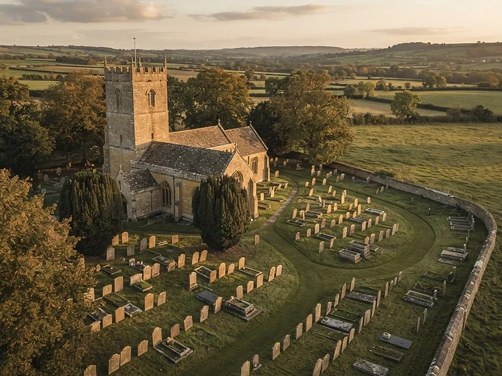 Pledex Memorial Map
 — cemetery mapping that finds, preserves and remembers.
The same aerial capture and digital mapping discipline we apply to commercial property, applied to burial grounds. A searchable digital map of a cemetery, with existing burial records linked to verified locations.
- Aerial cemetery mapping and an interactive grave finder
- Burial record digitisation and preservation
- Built for parish councils, churches and local authorities
Project Deliverables
Every project is tailored to the site and client requirements. Depending on the project, Pledex can provide a combination of the following digital outputs.
Interactive 3D Model
A detailed digital 3D representation of your property, site or asset that can be viewed from different angles and used to understand the site remotely.
- View the site remotely
- Understand buildings, land and surrounding areas
- Visualise the entire site in one place
- Useful for management, maintenance and planning
- Creates a lasting digital record
2D Orthomosaic Map
A high-resolution overhead map created from aerial imagery, providing a detailed visual overview of the captured site.
- Detailed overhead site view
- Understand layouts and boundaries visually
- View buildings, access routes and surrounding land
- Useful alongside the 3D model
- Creates a clear visual site record
Inspection Imagery
Detailed high-resolution photographs of specific buildings, roofs, façades, plant or other assets captured during the inspection.
- High-resolution inspection photographs
- Detailed views of difficult-to-access areas
- Images organised for easy review
- Useful for maintenance and contractor discussions
- Permanent visual evidence of site condition
Condition / Inspection Report
Where required, provide an organised visual report documenting the areas captured during the project.
- Selected inspection imagery
- Clearly identified areas of interest
- Visual site documentation
- Suitable for internal records
- Useful for maintenance and repair discussions
A Pledex report is a visual record of captured areas. It is not structural engineering certification or a professional building survey, unless separately commissioned and appropriately qualified.
Measurement Tools
Use the digital model to assist with understanding distances, areas and heights across the captured site.
- Distance measurements
- Area measurements
- Height measurements
- Useful for planning
- Useful for maintenance discussions
- Useful for site and contractor conversations
High-Resolution Aerial Imagery
Professional high-resolution aerial photographs captured during the project for documentation, management and appropriate marketing use.
- Professional aerial perspectives
- Detailed site documentation
- Asset and property imagery
- Useful for presentations
- Useful for marketing where required
- Creates a visual record of the property or site
Turn Aerial Data Into Practical Site Intelligence
Facilities Management
Inspect assets, maintain visual records, support maintenance planning and communicate site issues.
Property & Estates
Document buildings, roofs, façades, land and external assets across commercial property portfolios.
Construction
Capture site conditions, document progress and create visual records throughout a project.
Industrial & Manufacturing
Map operational sites, inspect buildings and create detailed digital records of large facilities.
Warehousing & Logistics
Capture warehouses, yards, access routes, roofs and surrounding infrastructure.
Quarries & Large Sites
Create detailed aerial maps, 3D models and visual records across large operational environments.
How a Pledex Project Works
Discuss The Site
We establish the site, objectives, required outputs and operational requirements.
Plan
Pledex plans the appropriate drone operation, capture method and project deliverables.
Capture
High-resolution aerial imagery and site data are captured safely and systematically.
Deliver
The captured data is processed into the agreed imagery, maps, models, reports and digital outputs.
Common questions, answered.
Need Better Visibility of Your Site or Assets?
Tell us what you need to inspect, map or understand. We can recommend the most appropriate capture method and deliverables for your site.